 Florida Resources and Environmental Analysis CenterFlorida Resources and Environmental Analysis Center
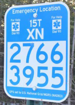
The US National Grid can identify any place on earth using simple alphanumeric characters. The USNG is considered to be the most reliable system for Search and Rescue missions, which explains why you see trail markers similar to the one here along trails and in national parks. The USNG is also mandated for use in multiple states during disasters as street address references could be destroyed.
In Florida, the Fire Marshall and the Division of Emergency Management have adopted this system for emergency response and for data transference with FEMA.
The USNG locational system can easily be converted to a GIS data model simply by adding GIS data!
For more information on the USNG Spatial Data Model, visit usng-gis.org for examples and downloadable data.
There are many benefits to using the USNG as a GIS database:
Find out more at usng-gis.org.